Introduction
In this weeks activity we explored the topic of mission planning and preparation for a data collecting mission using a Unmanned Aerial system. We started in the lab getting the basic knowledge needed to plan a mission in 3DR Mission Planner software. Then the students were split into groups of three and each one experienced the different position and roles that members a flight crew would serve during an actual mission. They went through all the pre-flight checks, planned the mission and finished by arming and disarming the UAS. We were unable to fly because of poor weather conditions but hope to do that in the upcoming weeks of class. My role in this exercise was to watch as the students did all the inspections and give them assistance and tips as needed. As the UAV technician and pilot for the geography department I have done this same procedure many times during real flights but helping teach the students the process forced me to pay more attention to detail and not just go through the motions.
Having the students learn these procedures and techniques gives them a much better understanding of what all is involved in data collection with UAS. It is more time consuming and complex than many people think. There are many safety, privacy and other consideration that need to be taken into account before during and after a mission. By seeing this whole process from start to finish it gives them a new area of knowledge which they could apply to research here at UWEC or out in the work force once they graduate.
Study Area
This exercise was conducted here on campus in the campus mall area (Figure 1). The weather was not very ideal which is why we did not fly any of the missions the students created, as previously planned. It was in the mid 70s very cloudy and humid with winds around 5 MPH out of the SSE. Since we were on campus there were many people walking past and observing what we were doing. This is a little bit of a safety hazard but since we were not actually flying the missions it was OK. Being aware of your surroundings at all times when out in the field is essential, especially when using UAVs. A few of the platforms we use can very seriously injure or kill someone so vigilance and taking every precaution to make sure the study area is clear is vital to safe data collection. Another reason we would not have flow in this area is there are numerous trees, bushes garbage cans and other objects that could get in the way of landing or take off. GPS health is also another concern in the campus mall because there are so many tall brick buildings. Large structures will often times reduce or even completely block GPS signal from the UAS platform. Strong GPS health is vital to a successful mission so again the campus mall is not a good place to fly. I hope all the students made some of these observations as well. Being a pilot is much more than just knowing how to fly you have to be aware of everything going on around you, weather, people, obstacles, and the aircraft.
 |
| Figure 1 This is an aerial view of lower campus at UWEC. The orange square labeled study area is where the activity took place. As you can see there are lots of large buildings around this area which make it a very bad place to fly. Issues with GPS health and also being able to see the UAV as it is flying are two of many factors that make this a very poor place to actually fly a mission. |
Methods
Planning Missions
The first part of the activity was indoors in the lab learning how to use Mission Planner which is an open source software created by 3DR. The first step to planning a mission is knowing where you want to fly or your study area. Once you have your study area chosen and travel to that location the next thing to do is create your flight path and data collection mission. When creating the mission there are a few things to keep in mind as far as legal areas to fly. Built into this software are the no fly zones in the United States. No fly zones are areas over airports, military bases, the White House and other important high security areas. It is illegal to fly a UAV in these areas and if caught you will be severely fined or sent to jail. In mission planner these areas show up as pink circles and purple areas (Figure 2). Make sure your study area is not in one of these spaces. The mission planner software communicates with the auto pilot on board the UAV and tells it where to fly. There are many other parameters that can be set in this program as well such as altitude, flight speed, how often to collect a picture, and what to do at each way point ascend, descend, land etc. To draw a flight path you draw a rectangle with a mouse on the screen and then based on the parameter you have set Mission Planner fills in the flight grid (Figure 3). You can also manually enter the way points like I have done in figure 4. Once it creates the grid it will tell you an estimated flight time which is good to know because these vehicles do have a limit on flight time. Once you have your mission drawn you can get ready to fly with the next step.
 |
| Figure 2 This is showing those no fly zones that are built into the software. You can see the pink circles indicating airports and the purple circles are over government buildings and other no fly areas. |
 |
| Figure 3 This is what a auto waypoint mission looks like. I tell Mission Planner what area, sensor, altitude, and platform and creates a mission grid based on those parameters. Just like when I manually made a mission you can see the list of waypoints at the bottom of the screen, I can still go in and make changes to those even though the mission was auto created. |
 |
| Figure 4 This is a screenshot of Mission Planner. I have manually drawn out a flight path for a mission over the soccer park here in Eau Claire. You can see at the bottom of the image where you can set all the parameters for each point in the flight. If I were connected to an aircraft it would also tell me an estimated air time for this flight. It is important that these flight lines are close enough together to ensure the correct amount of image overlap. We shoot for 80% overlap and this program will adjust the flight path to accommodate that depending on which sensor you are using. |
Pre-Flight Checklist and Notes
This next step is the most important. Professor Hupy and I after some crashes and other growing pains in our research with UAV's came up with a pretty extensive checklist to go through prior to putting any of the UAV's in the air. Once the mission is created and the UAV is assembled going through the checklist is essential. We use the checklist shown in figure 5. We check the weather, all connections both frame and electrical, prop and motor check, battery and antenna check, controller and command center, battery voltage, number of satellites, mission sent to UAV, check takeoff area for people and then clear for launch. I haven't read the whole list but this gives you an idea of how many things we check. We
check everything we can think of
every time we fly. This is the golden rule of using UAV's. It is over looked many times and that leads to accidents which cost money and can damage property or even kill someone. Notice how the majority of this checklist happens before the aircraft is powered up, there is a reason for that. Once the UAV is powered up reducing the time someone is around it adjusting things the better. An accidental arming of aircraft could result in loss of fingers or worse depending on the platform. After every flight we take notes about the flight in a log book we have created as well. This is more to do with battery charging, post flight maintenance of the vehicles if needed and data processing. Figure 6 is a screen shot of the other excel sheet we use to keep track of all of our flight data.
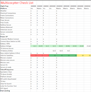 |
| Figure 5 This the pre-flight checklist we go through before every flight. We do not fly until there is a check by each row. Like I stated earlier this helps us to fly safely which is many times overlooked because people think UAV;s are just toys and that they aren't dangerous. We know the dangers and use our checklists! |
 |
| Figure 6 This the spreadsheet where we keep all the information about each flight. We record battery voltages, weather info, maintenance needs and suggestions for what to do better on the next flight. |
Mission Execution
We did not fly any mission in class but this is the procedure if we had done so. Once the the pre-flight checklist is complete the next step is to fly the mission. Part of the checklist is sending the mission to the UAV's auto pilot. Once this is done the aircraft is armed. After we are sure the area is safe we prefer to take off manually to about 10 meters height and do a stability and normal function test. We place it into loiter to see if it is functioning properly and can hold its position, if everything looks good it is flipped to auto pilot and it begins to fly the previously created flight path. During the flight there are a couple different jobs the crew flying the UAV need to perform.These are the 3 postions we had each of the students go through and learn what their role would be during an actual flight. One is the pilot at the controls (PAC) who has the controller in there hands and is piloting the aircraft. Another is the spotter who keeps an eye on the UAV at all times while it is in the air to make sure it is flying normally. The third person is the pilot in command (PIC). This person sits at the command station and watches the diagnostics on the Mission Planner screen (Figure 7). The PIC watches diagnostics like battery voltage, number of satellites, altitude, air speed, pitch, yaw, roll and that the aircraft is following the planned flight path. If anything looks suspicious this is the person who can abort a mission.Conducting research with Dr.Hupy we have aborted mission and safely landed. One time I was at the laptop and saw that the UAV was deviating from the flight path and the spotter observed it acting rather strange in the air. I made the decision to say abort mission and the pilot at the controls, professor Hupy, said aborting mission and put the aircraft in RTL mode. RTL mode stands for return to launch. If at any time during the mission this switch is flipped the UAV stops whats it is doing and returns to where it took off from and lands itself. The mission may not have needed to be aborted however as a safety precaution I decided to abort.
 |
| Figure 7 This is the display that the Pilot in Command watches as the UAV is in the air. You can see altitude, speed, battery voltage and other vital information is displayed here. If there is a catastrophic failure on board the UAV it will tell you on this display. If the GPS failed for example where it says DISARMED on the screen it would say NO GPS or GPS FAILURE in big red letters at which the mission would be aborted. |
Discussion
I think this activity was very good for the other students how complex of a procedure collecting aerial imagery with a UAS really is. It is not an activity that should be taken lightly or done by someone who does not have much experience in the field because it can be very dangerous for both the flight crew and observers if done incorrectly. I hope it sparked so interest in the students to pursue this technology as part of their research. It is a very skill set to have and will make them much more marketable once they graduate UWEC. In my time being the GEI technician I have seen opportunities and had many valuable experiences in connection with UAS technology that have increased my knowledge on the topic and helped me to better connect it to my GIS and other geography techniques. I hope we can conduct an actual mission with the students in the next few weeks so they know how this process goes from start to finish and even into the processing of the imagery collected during that flight in class.


No comments:
Post a Comment